Holyoke Canoe Club - Circa 1899
Two photos of the second canoe club that was built in 1894 on the banks of the Connecticut River about a half a mile south of the Dinosaur Tracks.
Looking up the Connecticut River at a point near River Terrace. The Canoe Club can be seen in the left of the picture.
The Canoe Club's history dates back to mid 1880s when the first canoe club was built just below the present day Pulaski Park just above the dam, north of the gatehouse. The second canoe club lasted until 1900, when the present canoe club in Smith's Ferry was built.
In this photo taken from the shore of the Connecticut River on River Road near Tiger Lane in South Hadley, above the canoe club you can see Kenilworth Castle which was built around 1895 and owned by E.C. Taft, founder of the Albion Paper Co.
Taft, who resided in a home on Suffolk street in the city of Holyoke, moved into the Castle in 1897, but died after only one week of residence there.
Also visible in the photo is the first Summit House on Mt. Tom which was built in 1897 and was destroyed by fire in 1901.
Friday, March 22, 2013
Thursday, March 21, 2013
High & Dwight street Circa 1920
Downtown Holyoke was bustling during this era. The population of Holyoke hit it's peak in the 1920s when 60, 203 people called Holyoke home. In this photo looking south from Dwight street, not much has changed in way of architecture while the trolley service ceased in 1936.
Wednesday, February 20, 2013
More Photos Of The Mt. Tom Railroad
Promo for the Mt. Tom Railroad and Summit House.
A cabinet photo from around 1880 showing a clearing for what would eventually become the trolley route from Mountain Park to the Lower Station of the Mt.Tom Railroad. This is now part of road to the old Mt. Tom Ski Area. (Photo courtesy of the Seminole Bailey Archive)
The trolley tracks entering Mt. Park from the Holyoke city route which originated at the old Post Office on Race Street. (photo courtesy of the Seminole Bailey Archive)
The route worked it's way west on Dwight Street to City Hall, south to Appleton Street, headed west to Pleasant Street, then north to Lincoln Street
It then headed west on Lincoln to Route 5 and north to Mt. Park. In the early days the trolley was the only way to enter the park. It cost 5 cents to take the ride.
A photo of the trolley line that ran between Northampton and Mt. Park. The tracks are seen just above the area between what is now Cedar Hill Road and Route 5. (photo courtesy of the Seminole Bailey Archive)
Trolley in the area of the base of Little Mountain heading back towards Northampton from Mt. Park. (photo courtesy of the Seminole Bailey Archive)
A couple of photos of the original trolley depot and restaurant at Mt. Park. LIttle Mountain and the viewing tower atop it's summit can be seen in the background.
A view of the Connecticut River and the city of Holyoke from the view tower atop Little Mountain.
The trolley line that connected Mt. Park to Lower Station of the Mt. Tom Railroad.
The Mt. Tom Railroad had two cars that took passengers to the Summit House atop Mt. Tom. Here the Rowland Thomas awaits passengers to take the mile long journey up the mountain. (photo courtesy of the Seminole Bailey Archive)
The other car, the Elizur Holyoke leaving Lower Station.
The start of the railroad at Lower Station. This section of track was level for a few yards before ascending the mountain at a 21 percent grade to the summit.
The Elizur Holyoke and Rowland Thomas just passing each other at the "Turn Out".
The Elizure Holyoke at the "Turn Out" heading to the Summit House in the summer 0f 1930. The photo was taken from the Roland Thomas which was heading back to Lower Station. (Seminole Bailey Archive)
One of the cars at the "turn out" heading to the summit.
Looking down the railroad at the "turn out" and Lower Station.
The Rowland Thomas just past the only turn on the railroad.
About three-quarters up the rail...
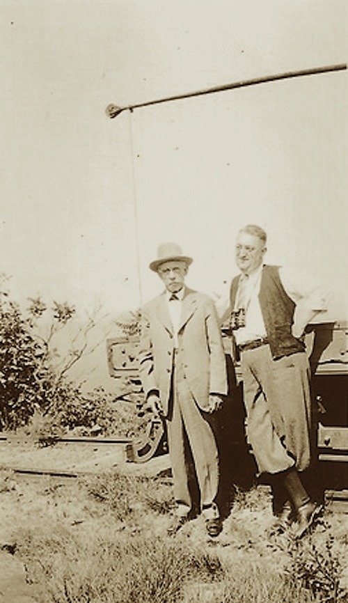
Two gentlemen standing next to the supply rail car near Upper Station in June of 1934. (photo courtesy of the Seminole Bailey Archive)
The north side of the first Summit House and supply rail in 1899.
Upper Station. Also seen in this photo is the supply rail that was used to bring goods and supplies to the Summit House.
Monday, February 18, 2013
The Holyoke House
The Holyoke House built in 1850 was located at the bottom of Depot Hill along Dwight street between Race and Main streets and was owned by the Parsons Paper Company.
In the Spring of 1890, Parsons, which had purchased the hotel for $32, 500 in 1864, spent another $40, 000 on renovations and changed it's name to the Hotel Hamilton.
The Holyoke House now known as the Hotel Hamilton in a photo taken in the late 1890s after remodeling and renovation work.
The Hamilton was purchased by Joel Russell in 1911 and housed the J. Russell Hardware Store on the ground level of the building.
The hotel closed in 1943 and several years later underwent another round of renovations, including the removal of most of the hotel's top floor. The building was home to many local government agencies up until recently, but is now vacant with it's future uncertain.
The Holyoke House built in 1850 was located at the bottom of Depot Hill along Dwight street between Race and Main streets and was owned by the Parsons Paper Company.
In the Spring of 1890, Parsons, which had purchased the hotel for $32, 500 in 1864, spent another $40, 000 on renovations and changed it's name to the Hotel Hamilton.
The Hamilton was purchased by Joel Russell in 1911 and housed the J. Russell Hardware Store on the ground level of the building.
The hotel closed in 1943 and several years later underwent another round of renovations, including the removal of most of the hotel's top floor. The building was home to many local government agencies up until recently, but is now vacant with it's future uncertain.
Connecticut River Railway Station - Depot Hill
The first railway station in Holyoke was located at the base of Depot Hill just north of what is now the Sullivan Steel scrapyard.
This station served the public up until around 1883 when the more elaborate station designed by architect Henry Hobson Richardson was built.
In the background is the area of Canochet Park where the Indian archeology dig by William J. Howes took place. This area eventually became the B&M freight yard and was active well into the 1970s.
Tuesday, January 29, 2013
Canonchet Park & Depot Hill
Looking Northwest from Canonchet Park in the late 1880s. To the left in the background Merrick Company Mills, City Hall (center) and the Mt.Tom range. Canonchet Park was located on what was known as Depot Hill.
Canonchet Park was located in the area that was bordered by Pequot, Oneco and Samoset streets (Pequot Street was eliminated to make way for construction of McNally Field)
The streets were named after Indian tribes and just north of Canochet was one of the major Indian archeology digs which was organized by William J. Howes. A section of where the park was situated is now Deroy Park, located in front of the Marcella Kelly School.
A view of the city looking east from Depot Hill. To the right of the picture looking up Dwight Street are the Hotels Jess and Hamilton, and further up, the Windsor. Also visible on the northeast corner of High Street is the original Second Congregational Church.
A view of the corner of Main & Dwight streets from Depot Hill in the late 1890s.
This photo was taken in front of the Look-Out platform near the area where the not yet constructed foot bridge that served as a short cut to the flats for over a century was located.
Monday, January 21, 2013
The Hagenbeck-Wallace and Forepaugh-Sells Brothers Circus at Springdale Park in the summer of 1935
Circus horses standing around one of circus train cars. This photo was taken near the area north of Jed Days Landing.
Notice the Elmwood section of Holyoke in the background. It gives you perspective to where this photo was taken.
Billboard advertising the 1935 movie "China Seas" starring Clark Gable and Jean Harlow. The other billboard mentions the 25th anniversary of American ??? Does anyone know?
Subscribe to:
Posts (Atom)