Thursday, December 5, 2013

Holyoke Archway Aqueduct


The Holyoke Archway Aqueduct was located next to the original Gatehouse near the dam on the Connecticut River.(this area can be seen from Pulaski Park's eastern most balcony.) 

Built in the 1870s, it carried water to the city's first reservoir, which was located on the parcel of land that bordered Fountain Street to the north, Lyman Street to the south, High Street to the east and Maple Street to the west.

The reservoir supplied water to the city up until around 1873, after which in 1875, the site was filled in and construction began on one of Holyoke largest tenement buildings, the Dillon Block.  Pulaski Heights and Kosciuszko Park now take up most of this area.


The aqueduct under construction in the 1870s. Notice this photo predates the Boston & Main Railroad hence the absence of the dual railroad tracks that ran parallel to the river. (Photo courtesy of F. Forest & Co.)

Monday, October 21, 2013

Pavilion- Hampton Ponds circa 1906


       The pavilion which was located on the shoreline of old Camp Jahn beach.


Hampton Ponds located on the Holyoke /Westfield border was, and still is a beautiful place for recreation, especially in the summer months. Hampton Ponds State Park is located in the northeast corner of Pequot Pond. In the early years, there were many public beaches along it's shore, but most of the shoreline is now privately owned. 


Back in the early 1900s, it was a summer destination spot just off the trolley line that ran from Holyoke to Westfield. The remnants of this trolley line (above) is now a nice hiking trail that runs behind Holyoke Community College (there's still a beautiful stone trolley bridge on the route) and leads to Apremont Highway where it continued near the Holyoke /Westfield border at Fini's and onto Westfield.

Sunday, August 18, 2013

Elm & Appleton Streets - 1908


Looking north on Elm street at the corner of Appleton. The First Methodist Church can be seen on the northeast corner. Just north of the church is the apartment block The Jerome.


Across the street on the northwest corner is The Rutland. This apartment block still stands, and it's beautiful architecture can be appreciated the most at around sunset.

Saturday, August 17, 2013

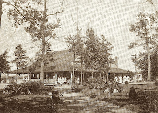
The Holyoke Country Club


The Holyoke Country Club was built in 1906 on farmland that was formerly owned by A. Waters. The land at the time was actually part of the Ward Four section of Northampton, which was not annexed to Holyoke until 1909.


The State Legislature's approval of the annexation of the Smith Ferry section of the city came about due to the discontent of residents because of the seasonal unreliability of the main connecting road though the Oxbow, which made two-way travel difficult (this section was physically separate from the rest of the city by a thin section of Easthampton.)


Often the Holyoke Fire Dept. had to respond to fires in what technically was Northampton. The Smiths Ferry section included land from Mt. Park north to the Oxbow.


The owner's of the club remodeled Waters' farmhouse and it became the golf course's clubhouse,  after which they also added tennis courts in the front of the property.


The courts were later removed for added parking space and part of this area was later cut off by the construction of I-91.


Over the years there have been many improvements and additions to the original house. The eastern section of the property went through a few changes in the early 1960s when the entrance to the club was altered due to the construction of Interstate 91. 


In 2012 the Holyoke Country Club was sold to area business man Eric Suher for a reported $850, 000. At the time, it was unknown what Suher's reason and plans were for the purchase.


Club officials hope that Suher keeps the site as a golf course, but that wasn't a condition of the sale. As of 2013, the Holyoke Country Club is still going strong enjoying it's 106th year.


The Waters farmhouse in the early 1900s prior to the construction of the Holyoke Country Club.


The original entrance to the Holyoke Country Club early 1900s. The location is just north of the present day Delaney House. The construction of I-91 altered this entrance in the early 1960s.


The clubhouse buildings circa 1930s. The original Waters farmhouse is shown on the right.


A view of the First Tee looking north with the foothills of Mt. Nonotuck in the background.


A very early photo of the clubhouse and tennis courts.  The Mt. Tom Range is in the background. The Waters Farmhouse was converted into the clubhouse in 1906.

Notice on the left many of Waters' farm buildings are still standing. Just south of those buildings would be the first entrance to the Mt. Tom Reservation in 1903.  The area just in front of the tennis courts is where I-91 is now located.


Friday, July 26, 2013

John B. Sutcliffe

Holyoke & Vicinity


These photos are from a stereo view series taken by Holyoke photographer John B. Sutcliffe in the late 1890s. 

In addition to his stereo view photography, Sutcliffe also photographed  many historic events in and around the city including President McKinley's visit to the area in 1899, and the December 1906 fire at the southwest corner of Dwight and High streets.

The locations of the above photos are unknown, but the top photo was most likely taken somewhere in the Highlands. The gentleman in the Civil War era uniform brought to mind William Stiles Loomis, but i'm sure it's not him. (???)

The middle photo might have been taken in the area known as "High Rock Springs" along the old B&M Railroad line near the Connecticut River.  Again, this is only a guess..

The bottom photo appears to have been taken at the Holyoke Ice Company which was located just west of Pulaski Park near the banks of the Connecticut River,  

Tuesday, July 23, 2013

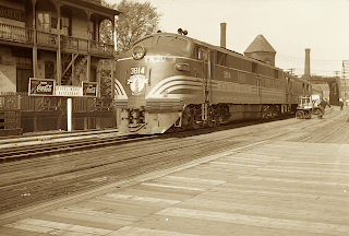
B&M Railroad - Holyoke Railroad Station


The Boston & Maine 3814 passenger train on the southbound rail making a stop at the railroad station in the "flats" section of the city. The passenger route through Holyoke was part of the old "Montrealer" run from Montreal to Washington D.C. 

Also seen in this photo from 1949 is the rear section of the Hotel Monat which was located across from the station on the west side of the tracks at Main & Mosher streets. (Photo courtesy of Seminole Bailey)

Sunday, July 21, 2013

The Valley Arena


Located on South Bridge Street in Holyoke, MA, USA, the Valley Arena opened in 1926, when Homer Raineault converted the "Gas House" into a boxing arena. He ran it until he died in 1944, when his nephew, Oreal Raineault, took over. Shows were on Monday nights. (In 1936, ticket prices were 40 cents.)

It was known as having a great atmosphere, with foot-stomping and hand-clapping. Big bands appeared there on weekends (including the Dorseys, Glenn Miller, and acts by boxers Max Baer and Maxie Rosenbloom). The venue also presented wrestling.

Many well-known fighters appeared here, including Rocky Marciano (who made his pro debut here), Willie Pep, Sandy Saddler, Beau Jack, Sixto Escobar, Lou Salica, Fritzie Zivic, Paddy DeMarco, Tony DeMarco, and Lou Ambers.

Joe Louis refereed a wrestling match here, and Jersey Joe Walcott fought an exhibition. Visiting boxers usually came by train or bus from New York and slept above Kelly's Lobster House.

The arena twice burned to the ground (on June 13, 1943, and 1952) and was restored (re-opening the second time in May 1953). It closed for good on May 12, 1960, when it was destroyed by a third fire. (Wikipedia)


Monday, July 15, 2013

Craft's Tavern


Craft's Tavern was built in 1785 by Archibald Morgan and at one time was one of the two oldest buildings in Holyoke. It was located on Northampton Street on the present site of the John J. Lynch School. 

Morgan, who was owner of the property, leased the building to Abner Miller, who ran the Abner Miller Inn there until 1832. Just north of the tavern was the First Congregational Church, which was built in 1834.

It was in the year 1832 that Chester Craft purchased the property and ran it as a tavern, post office and general store until 1872, during this time it was a twice a day stop on the Old Post Road mail route from Springfield to Hanover.

In 1926, the Daughters Of The American Revolution marked the property as an historic spot, and in 1928 the land was leased by the city of Holyoke, (who had taken ownership of the land in 1882), to the Eunice Day Chapter of the Daughters Of The American Revolution who opened it as a regular tavern.

Years later, the city which had taken 47 acres of land behind the tavern in the early 1880s for a park which later became Anniversary Field, and who also intended on making Craft's Tavern a museum, demolished the building to make way for the future John J. Lynch Junior High School which was built in 1952.  (Photos courtesy of The Seminole Bailey Archives)


Monday, June 10, 2013

Holyoke Turn Verein - 1899


Two bartenders posing for this picture at the Turn Hall located on South Bridge Street. Notice the Camp Jahn advertisement over the shoulder of the bartender on the right. For close ups, see the photos below. (courtesy of the Seminole Bailey Archive)


Hmm, 1:45 a.m.? I think last call came and went. Okay boys, time to clean out the spittoons.

Friday, June 7, 2013

Company D 104th Infantry 1917


Massachusetts Governor Samuel W. McCall looks on from the reviewing stand in front of City Hall at High and City Hall Court as Company D 104th Infantry Reg. marches in the Farewell Parade on their way to battle on September 19, 1917. (photo courtesy of The Seminole Bailey Archive)


The 104th Infantry Band performed in the Farewell parade on September 19, 1917. (photo courtesy of The Seminole Bailey Archive)

Anti-Aircraft Gun Presentation 1941


High officials of the government and Worthington Pump executives along with hundreds of onlookers attend a presentation of the 90mm anti aircraft gun carriage that was manufactured at Worthington's Holyoke plant.


The presentation took place on October 24th 1941 in front of the Fire Department headquarters across from Veteran's Park on Maple Street. (Photos courtesy of The Seminole Bailey Archive)


Tuesday, May 28, 2013

Senior Building & Dooley's Inn circa 1906


The Senior Building on the southeast corner of High & Appleton streets. The ground floor was home to Senior Brothers Clothiers. The building is now occupied by the NewAlliance Bank and has gone through an extensive renovation recently.


Heading east behind the Senior Building was Dooley's Inn located at the southwest corner of Bond & Appleton streets. Dooley's was originally known as Yoerg Inn which opened in 1901 and named after it's owner, Kraig J. Yoerg. He sold the property in 1912 to Patrick Dooley and it remained open until the early 1920s.  (Photo taken from an eBay auction)

Saturday, May 18, 2013

Cedar Knob and the Crag 1890s


This photo taken from the viewing tower atop Little Mountain shows the summer home of William Stiles Loomis at the area on the eastern side of Cedar Knob known as the Crag.

The Crag was the only property Loomis kept for personal use of the 385 acres he purchased as head of the Holyoke Street Railway for the construction of a trolley park in 1894.

The park would eventually be known as Mountain Park.  Also seen in the picture is the three story viewing tower atop Cedar Knob.

There were actually three towers in the area. In addition to the Little Mountain and Cedar Knob towers, there was a third tower just north of Little Mountain on the west side of I-91.

In the background is the Connecticut River and the "High Rock" area near Jones Point.  Today I- 91 runs through the bottom of the western slope of Cedar Knob .


A view of the Connecticut River from the third tower looking southeast towards the city of Holyoke. In the foreground is Thorpe Road (Route 5) with the William Stiles Loomis Crag property on the right.

Friday, May 17, 2013

Mt. Park Casino via the Northampton Street Railway 1912


The Northampton and Holyoke Street Railways operated a trolley route from Northampton to Mountain Park. The rail bed can be seen in the "treeless" area to the left above the trolley car. The route existed from the early 1900s to the 1930s.

This route crossed the present day RT 91 and went north towards the area that is now the northbound scenic area and exited onto RT 5 between Cedar Hill Road and Falardeau Drive. The route then proceed along RT 5 north towards Easthampton to Northampton.


A trolley from the Northampton Street Railway makes a stop at the Mountain Park Casino in July of 1912.  (This photo was taken from the roof of the Trolley Pavilion and is courtesy of the Seminole Bailey Archive)


Part of the rail bed still exists today as an entrance road to Mountain Park, then running parallel along the Mt. Tom Ski Area Road around the base of Little Mountain towards Route 91.

You can also see traces of the rail bed if you cross over to the east side of Route 91 near the old Mountain Park Junk Yard between RT 91 and Rt 5 and again further north by the I-91 Scenic Rest Area  Notice the boulder in the picture, it's still a landmark at the park. (Photo courtesy of the Seminole Bailey Archive)


This photo of the Northampton to Mountain Park trolley route was taken in the vicinity of the old Davignon Farm just below the location of the present day rest area on I-91. The Connecticut River and Route 5 are in the background. (photo courtesy of Robert Schwobe)


Switch track in the vicinity of the old Davignon Farm just  east of the present day northbound Rest Area on Route 91.


The Northampton to Holyoke trolley route as it looks today. In the top photo, the last bridge that was constructed for the line in 1924. In the bottom photo, the rail bed. Both these photos were also taken in the area of the old Davignon Farm near the Route 91 northbound rest area.

Saturday, May 11, 2013

Holyoke Y.M.C.A. 


Three photos of the Y.M.C.A. at the northwest corner of High & Appleton streets in 1905. The building stood until 1943 when it was destroyed by fire.

The Greater Holyoke Y.M.C.A. has proudly served the community since 1886. The world’s second most played sport – volleyball – was invented in 1895 at the Greater Holyoke Y by William Morgan.

There’s a detailed history of Volleyball’s creation and early evolution on the International Volleyball Federation WebsiteInternational Volleyball Federation Website (FIVB).

The Greater Holyoke Y was first located at the corner of Appleton and High streets in downtown Holyoke. The site included a gym and rooms for rent. Unfortunately the building was lost to fire in 1943.


In 1950, a second building was completed at the corner of Appleton and Beech streets. This photo, courtesy of the Holyoke Y.M.C.A. was taken from the now extinct Chase Avenue which bordered the Y on it's north side. The street which ran east-west connecting Beech with Pine was eliminated when the Y built a new addition to house it's pool several years ago.  (holyoke ymca.org)

High Street 1905


Looking south down High street near the intersection of Suffolk street in 1905. This view hasn't changed much since, with most of these buildings still standing.

Gone of course are the A.T. Gallup building on the southeast corner of Suffolk & High, and the Y.M.C.A. building further south on the northwest corner of Appleton & High.

Friday, May 10, 2013

What A Beautiful View!!!


This is a photo taken in the early 1900s from a location near the present day McNulty Park and long before the Muller Bridge and causeway project would alter the flow of the river and size of the cove.

There are many landmarks seen in the picture that no longer exist, including the Saw Mill below Mitchell Field and the original Ice House near Prospect Park.

This is another spot in the city hidden by overgrowth and because of that, denies a spectacular view of the river and city looking east, and the Mt. Tom and Mt Holyoke Ranges to the north. 

The city claims one of the main reasons that clearing efforts are stifled, is because of erosion problems that threaten the Pan Am railroad tracks below. Of course this is bull since the railroad existed when this photo was taken,  Pulaski Park experiences a similar problem.


This photo taken in 1899 from the Summit House dining room shows the eastern slope of Mt. Tom with Whiting Street Reservoir and the Connecticut River in the background.

In between the two bodies of water sits Mountain Park. If you look real close, you can see Lower Station in the middle left of the picture and the road leading to the Botanical Garden on the right.

The rail in the picture is that of the supply track that transported supplies and goods to the Summit House via a special car.

Where the track was located is now part of the road that leads to the transmission towers atop the mountain. Notice the beautiful grassy area on the slope. Today this area is buried with debris and it's view obstructed with sumac trees and various other growth.