
Terms of the lease were that for the first two years the rent would be free, and fifty dollars a year thereafter.(These terms were agreed upon until 1875, when William Street purchased the property of the original lease).
In March of 1861, Street & Farnum began construction of the hotel, along with landscaping the grounds which included a picnic area. croquet field, walkways and a scenic vista on the peak's northern edge. Access to the hotel was by a cart road located on East Street in Easthampton and also by several hiking paths.
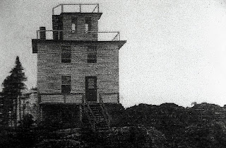
The hotel began as a small structure, 22x26 feet that included five guest rooms, dining room and parlour. The building also included an office, and on the top of the structure, an observation room for spectacular views in all directions. To furnish water for the hotel, a dam was built across a natural spring on the lower east side of the mountain and was brought to the hotel by water buckets carried on the back of a mule.
In August of the same year, Street & Farnum had a disagreement which resulted in Farnum's departure.Though the reason for the disagreement is unknown, perhaps Farnum wanted to return full-time to his painting and wallpaper business in Holyoke. With Farnum out of the picture, Street would begin a forty year venture as manager and proprietor of the Eyrie House Hotel.
In 1870 Street began the first of three additions of the Eyrie House. Construction began on adding five more guest rooms and a veranda that included a telescope. To cover the cost of the addition, Street increased the rates at the hotel which had been six dollars a week, to seven dollars a week.
The late 1870s and early 1880s, William Street acquired more property on the mountain that saw two more additions including twenty more guest rooms, billiard room, woman's parlor and men's smoking room. The construction also included the North & South Promenades, a children's swing, a Look-Out Tower and Pavilion. Also a new water source was also added, Street purchased a steam powered water pump that pumped water from a well located on the west side of the mountain up to the hotel by pipe. A windmill was also constructed for power.
The 1880s were the "golden days" of the hotel, which was being patronized by several hundred people a day. On July 4th, 1885, the hotel was visited by 600 visitors who came to either dine in the hotel's dining room which featured exquisite meals including roasted Ribs Of Beef, Spring Lamb, Veal along with New Potatoes, Green Peas, Beets and an assortment of Pastries and Deserts. Or bring their own picnic baskets and enjoy the fresh mountain air and after dinner stroll the grounds which also included a menagerie of animals,birds and reptiles. In addition to a croquet field and picnic area, the grounds also included a pavilion, shooting range and bike path.
The beginning of the end started in the 1890s, when the amount of visitors to the Eyrie House
declined. Most of his patrons were the regulars who would rent the hotel for company outings. Overhead was high, the hotel being a wooden structure, was becoming harder to insure.
So in 1893 while the hotel was still operating, William Street started construction on a new hotel and an incline railroad. The new hotel would be a massive structure, three stories of stone, and one of steel. Entry into the hotel would be from an incline railroad that ran up the north west side of the mountain to a trestle where the railroad crossed into the ground floor of the new hotel. This was to be the only way to enter the structure.
While construction was started on the new hotel, another entrepreneur, William Stiles Loomis, who was president of the Holyoke Street Railway, was beginning plans to open a trolley park on the southern end of the mountain range on Mt. Tom. His plans also included a summit house and incline railway.
And in 1895, Mountain Park was opened to the public followed by the construction of the Mt. Tom Railroad and Summit House.
Meanwhile William Street's original Eyrie House was falling into disrepair, and with a lack of patrons who were now spending time at Mountain Park, Street was having finical difficulties which prevented the finishing of his new hotel. The final blow came when Street was informed by the state that they were planning to take his land by eminent domain for a state reservation. But before this happened fate stepped in.
On April 13th 1901 while William Street was preparing for the opening season of the original hotel, he discovered that several of his work horses that were kept in a stable underneath his pavilion had died. Since there was no way to bury the horses on top of the mountain, he decided to start a fire near the stable to cremate them. After the cremation and when the fire had died out, Street retired for the evening, only to be awakened a few hours later by the light and roar of a fire.
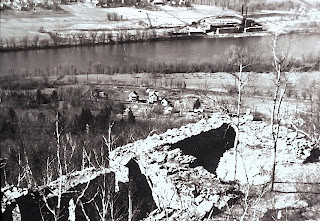
The fire had rekindled and started the stable and pavilion ablaze. Street tried to extinguish the fire and keep the blaze from spreading up the mountain to the hotel. But his efforts were in vain, The Eyrie House was no more, the hotel had burnt to the ground. All that remained were the walls of the foundation, and the rubble of the toppled chimney.
The Eyrie House had sustained 10,000 dollars in damages and was only insured for 2000 dollars.
In a gesture of goodwill, the state, who had plans of rebuilding the hotel when Mt. Nonotuck became part of the reservation, offered Street 5000 dollars for the property. But Street said his land was worth 25,000 dollars and refused their 5000 dollar offer.
So a few years later, the state deposited a 5000 dollar check in Street's bank account and took the land by eminent domain ending William Street's forty year reign on Mt. Nonotuck.
Street would end up a lonely, disillusioned man, he died in 1917 at age 78 never cashing the 5,000 check.
At the time of it's existence from 1861 -1901, the Eyrie House was located in Northampton Massachusetts and was situated atop Mt. Nonotuck, the northernmost peak of the Mt. Tom Range. which was part of Northampton's Ward Four district. It wasn't until 1909 that the State Legislature approved Holyoke's annexation of most of Ward Four which also included the Smith's Ferry section of the city.
This section was physically separate from the rest of the city by a thin section of Easthampton. The discontent of these stranded Smiths Ferry residents was aggravated because of the seasonal unreliability of the main connecting road though the Oxbow which made two-way travel difficult. Often the Holyoke Fire Dept. had to respond to fires in what technically was Northampton. The Smiths Ferry section includes land from Mt. Park north to the Oxbow.
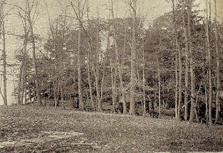
Picnic grove that was located at the foot of the west side of Mt. Nonotuck. Just to the left in the picture was William's Street's cart path that took you via horse and buggy to the stable area just below the Eyrie House.
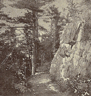
This path is now the beginning of the M M Trail that takes you along the Mt. Tom Range south to the Mt. Tom summit. It is located off Underwood Ave. in Easthampton.
The original cart path that led up to the Eyrie House from the stable area. (this area is now buried beneath the present day parking lot at the end of Nonotuck Road).
The original 22 x 26 Eyrie House circa 1861. (Photo courtesy of the Robert Schwobe Collection)
Eyrie House (1870 addition with extra guest rooms and veranda). (Photo courtesy of the Robert Schwobe Collection)
Eyrie House (Another angle from the southwest of the 1870 addition). (Photo courtesy of the Robert Schwobe Collection)
Inside of the veranda with telescope looking north toward Mt. Holyoke. (Photo courtesy of the Robert Schwobe Collection)
Charles, Lillian and Madams Gills & De Rey from Mt. Holyoke College pose for a photograph on the South Promenade during it's construction in 1883. (Photo courtesy of Donna Albino Mt. Holyoke College alumna)
Guests on the front promenade in the mid 1880s. The main staircase is on the left. I'm not sure what the structure in the foreground is, it appears to have been used to store supplies. It's been said that it was used as a construction table for the new hotel, but seems kind of low for that purpose. ??? Any comments?
Visitors enjoying an afternoon on the South Promenade late 1890s. The Connecticut River can be seen in the distance to the left, also visible is the front promenade.
Among some of the attractions at the Eyrie House was the Children's Swing located at the end of the South Promenade stairway. The swing was operated manually by a turning pole.
From a platform parents would strap their children into one of the swing's seats then head down to the turn pole and apply force to the pole while walking in a circular path.
As the pole turned, the swing's seats would arch out making for an enjoyable ride. (Top photo courtesy of the Seminole Bailey Archive, bottom photo courtesy of the Robert Schwobe Collection)
Visitors congregating on the South Promenade c1884 (the stairway at the end of the promenade led down to the children's swing and a pathway to the pavilion). In the background to the south is Dry Knob and to the west, the Ferry Street area of Easthampton). (Photo courtesy of the Robert Schwobe Collection)
A view from the South Promenade in the early 1890s. (Photo courtesy of the Robert Schwobe Collection)
South Promenade in the late 1890s (notice how the promenade is rundown and in need of repair, the hotel was vulnerable to the harsh New England winters). In the distance two women can be seen looking east on the observation tower while a few others are perhaps enjoying afternoon tea on the Front Promenade. (Photo courtesy of the Chas. J. Keene Archives)
North Promenade circa 1884. From the end of this promenade one had spectacular views of the Connecticut River and Mt. Holyoke Range. There was also a stairway that led down to Point Look Out and the picnic grove. (Photo courtesy of the Knowlton Brothers Archives)
Mount Holyoke College students on the North Promenade celebrating Mountain Day, May 16th 1884. (Photo courtesy of Donna Albino Mt. Holyoke College alumna)
Mount Holyoke College students pose for a picture at Point Look-Out Eyrie House grounds on Mountain Day May 16th 1884. (Smith College College celebrated their first Mountain Day here in 1877). (Photo courtesy of Donna Albino Mt. Holyoke College alumna)
A view of the city of Northampton and the Ox Bow taken from the North Promenade of the Eyrie House in the 1880s. (photo F.H. Putnam)
A pavilion was located on the eastern side of the mountain. It was used for company picnics and for other events such as dances and concerts. The pavilion was also used for roller skating, but was unsuccessful and discontinued after one season. Underneath the pavilion was a storage area and stable for Mr. Street's horses.
Through the years many outings were held at the Eyrie House. Here the Springfield Pharmaceutical Association poses for a picture in front of the hotel at their Sixth Annual Meeting on June 8th 1887 (Notice the gent with the double barrel shotgun, he must have took time out from the shooting range that was located on the east side of the hotel). (Photo courtesy of the Robert Schwobe Collection)
Clambakes were very popular in the hotel's picnic grove. (Photo courtesy of the Seminole Bailey Archive)
Hotel visitors enjoying the views on the cliffs near Point Look-Out
Two view taken from the Eyrie House looking down towards present day Route 5. The top photo shows the covered bridge of the B&M railroad spanning the inlet to the Ox Bow has long been replaced by the present day steel bridge. This photo predates Route 5 which can be seen in the bottom photo If you look behind the trees on the left you can see the intersection of old Route 5 and East Street. The old Steamboat Landing would be behind the trees on the right.
Visitors to the Eyrie House enjoying the view towards Mount Tom Junction. (notice in this picture the stairway is in great shape as compared to the photo below). (Photo courtesy of the Robert Schwobe Collection)
It is now the late 1890s and the Eyrie House is showing it's age. A lone visitor can be seen on the Front Promenade. (Photo courtesy of the Robert Schwobe Collection)
Tourists on their way to Smith's Ferry to take the horse & buggy ride to the Eyrie House in 1899. (Photo courtesy of the Seminole Bailey Archive)
A group of patrons (possibly celebrating a wedding) enjoy the view to the north and northwest toward Northampton. Pictured in the distance is the R.F. Underwood Farm and the Connecticut River logging business located at the Oxbow. (Photo courtesy of the Knowlton Brothers Archives)
Another beautiful view of the Connecticut River and Mt. Tom Junction. This photo seems to have been taken from the Front Promenade and shows the pathway leading up to the hotel. Also if you look closely, you can see the train station at the base of the mountain. (Photo courtesy of the Robert Schwobe Collection)
A view of the Oxbow looking northeast with Mt. Nonotuck in the distance. If you look real closely, you can see the Eyrie House on the summit. (photo courtesy of the Seminole Bailey Archive)
Here's a beautiful view of the Eyrie House and Mt. Nonotuck from the east
This photo was taken from Titan's Pier in South Hadley. ( Photo courtesy of the Milan P. Warner Collection)
Another view taken from Easthampton showing both the Mt. Holyoke summit house on Mt. Holyoke (left) and the Eyrie House on Mt. Nonotuck (right)
Various souvenirs from the Eyrie House circa 1880s. Pin Cushion, Letter Opener (book marker) and Egg, Indian Club containing spools of sewing thread.
1871 ad for the Eyrie House.
1880s Trade Card
The Dining Room of the Eyrie House Hotel including a menu.
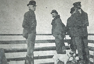
Proprietor William Street (left) on the front promenade of the Eyrie House circa 1890s. (Photo courtesy of the Robert Schwobe Collection)
An 1890s photo of Mt. Tom Junction. In the background is Mount Nonotuck, the area at the base to the right shows the clearing for the rail bed of the incline railroad that was to service the new hotel.
News article from the July 22, 1892 edition of the Boston Transcript announcing plans for the incline railroad that was to be built for the new hotel.
The aftermath of the April 13th 1901 fire that destroyed the Eyrie House Hotel. In this photo looking east, the foundation is all that remains, the rubble in the foreground was the hotel's fireplace and chimney. In the top photo, the north promenade is all but a memory.. (Top photo courtesy of the Seminole Bailey Archive, bottom photo courtesy of the Robert Schwobe Collection)
The only difference between this 1910 photo and the way the new hotel ruins look today is that they are about a foot lower thanks to vandalism. (Notice the unobstructed view of the Oxbow and vicinity). (Photo courtesy of the Robert Schwobe Collection)
Recent photos of various Eyrie House landmarks:
Location of the original 1861 Eyrie House on the Mt. Nonotuck summit.
The remains of the south foundation wall to the 1871 addition of the original Eyrie House Hotel.
The new hotel ruins. The new hotel when completed would have been three stories of stone and one of steel. Entrance to the new hotel would have been by trolley up the incline railroad crossing a hundred foot trestle and entering the hotel on the ground floor at the northwest corner of the building.
Location of Look Out Tower on the eastern slope of Mt. Nonotuck.
One of three remaining anchors at the Look Out Tower site.
Beginning of Incline Railway bed at the base of the mountain.
The Incline Railway bed at around the halfway point up the mountain.
Stone wall of original dam located on the eastern side of Mount Nonotuck. Water was transported from here by mule up a cart path to the hotel. Later William Street would get his water from a well on the west side of the mountain by installing a steam pump and pipe system to transport water to the hotel.
Main pathway around perimeter of the Eyrie House grounds, (notice the beautiful stone work).
Water well which is located on the western slope of Mt. Nonotuck.
Pump House that's adjacent to the water well.
Inside view of the Pump House.
Another photo of the original dam located on the eastern side of mountain.
Home of William Street which was located at 1657 1/2 Northampton St. Holyoke.
It was moved from the present 1661 Northampton St. site to another location in the city.




g~~_3.jpg)






8 comments:
thank you, it's very inspiring and helpful information.
regards,
airless spray gun
How do you knkw there was a lookout tower there?
Excellent job compiling this information.
Thank you for this wonderful story I never knew this! Hiking up there today
The structure at the bottom of the main staircase looks like a mount/dismount platform for horseback riders.
Wondering about the short platform on one picture that you weren't sure about. Could it have been used to make it easier to dismount a horse? Did some ride up there on horse?
Oops, I see someone else already write that
Hi there, I am looking for the contact of whoever owns the property the ruins are now on. I would like to discuss filming there and do not know who oversees this. Thanks!
Post a Comment