Wednesday, May 5, 2021

 More Mt. Tom Railroad Photos


    Two photos of the Elizur Holyoke leaving Lower Station for the Mt. Tom Summit early 1900s (Seminole Bailey Archive}


Mt. Tom Summit Photos Early 1900s

Visitors to the Mt Tom Summit relaxing on the South Basalt rock ledge with the Tea Pavilion in the background. (Photos courtesy of the Seminole Bailey Archive)
 

Another view looking south overlooking what is now Route 141. This is a photo taken during the 1930s and at the far right the CCC camp can be seen. The CCC built the roads and bridges and other structures in the Mt.Tom Reservation.  (Seminole Bailey Archives)


Looking west from what is now the Wycoff Country Club near Route 91. (Seminole Bailey Archive)

Thursday, May 28, 2020

1880s Reservoir Near Present Day Whiting Street Reservoir


The Original "Perkins" reservoir was located off the present day Aerator Road just as you take the "bend" opposite the brick gatehouse building. (Photo courtesy of the Seminole Bailey Archive)


Remnants of the original gatehouse foundation can still be seen... the area is now reforested and when the original dam was removed the reservoir dried up. 

The reservoir was replaced with the much larger Whiting Street Reservoir in the early 1900s which is located just west of this site. (Photo courtesy of the Robert Schwobe Collection)

Sunday, August 25, 2019

                  Snapshots Of Holyoke's Past:                                                                                                                                   

                 Main Street looking north at the intersection of Jackson Street circa 1949.     


  Area which later became McNulty Park overlooking the "Cove" and Old Ward 4 circa 1950. 


This photo was taken from LaFayette Street showing what is now the Stop & Shop parking lot on Lincoln Street. LaFayette Street was eliminated in the 1950s to make way for the new Providence Hospital but this location later became the home of Stop & Shop and J.M.Fields after the Sisters Of Providence decided to build the hospital on Main Street instead.


  Standard Tire Sales at the corner of Division and Railroad Streets. The area is now the parking deck just south of the District Court building and across from Heritage Park.

Saturday, June 9, 2018

Dwight Street/Veterans Park Vicinity - 1951


Looking west up Dwight Street near the intersection of Chestnut Street. The house on the left (does anyone know who's residence this was?) was demolished in the early 1960s to make way for the Flying "A" gas station.  West of the Post Office is the Urania Building that was the home of the P.O. Spa Restaurant for many years. This building was destroyed by fire several years ago and is currently being renovated. 


A look south up Chestnut Street from the corner of Hampden Street. 


Another view south from the intersection of Hampden and Chestnut Streets. (Photos courtesy of the Seminole Bailey Archive)

Wednesday, January 10, 2018

Hockanum Ferry - 1890s


A rare photo of the Hockanum Ferry docking on the Northampton Bank circa 1890s. 

In addition to being transportation across the Connecticut River, the Ferry was active in bringing travelers to the Mt.Holyoke Summit House and Eyrie House. (Seminole Bailey Archive)

Mt.Tom Railroad - Turn Near Upper Station


Looking up the Mt.Tom Railroad near the turn to Upper Station early 1900s. This photo was taken just above where the present day B-17 Memorial is located.

The turn was the result of William Stiles Loomis' decision on saving some trees that were in the railroad's original path to the Station. (Seminole Bailey Archive)

Holyoke Early 1900s


     Holyoke looking west from Willimansett Heights early 1900s (Seminole Bailey Archive)

Monday, April 17, 2017

Looking East Up Hampden Street Early 1900s


Street paving in the early 1900s. This is a view looking east up Hampden Street near the intersection of Pine Street. In the background is St. Jerome Church and School.  (Seminole Bailey Archives)


Friday, March 17, 2017

Mt.Tom Railroad


The Elizur Holyoke rail car at the Mt.Tom Railroad "turn out" on it's way to the Mt.Tom Summit House in the 1920s (Photo courtesy of the Seminole Bailey Archive)

Wednesday, November 9, 2016

The Original Montrealer/Washingtonian Route

The Montrealer/Washingtonian was named for the two cities the train served; Washington, D.C. and Montreal, Quebec.  This once popular corridor required five different railroads to complete the journey which included (from north to south) the Canadian National, Central Vermont, Boston & Maine, New Haven, Pennsylvania Railroad.  This, of course, was during an era of far more civilized travel, predating the airliner, and the trains provided first-class services during a trip that usually required around half a day to complete.  Inaugurated a few years before the Great Depression the Montrealer/Washingtonian would close out long-distance international rail travel in New England when both were discontinued during the mid-1960s.


The Montrealer pulling into the Holyoke rail station in the early 1960s. The depot station was designed by famed Boston architect Henry Hobson Richardson. Passenger trains stopped there until 1967, although the Montrealer would run through Holyoke until 1972. (Seminole Bailey Archive)

Tuesday, October 18, 2016

Mt.Tom Railroad - Circa 1902


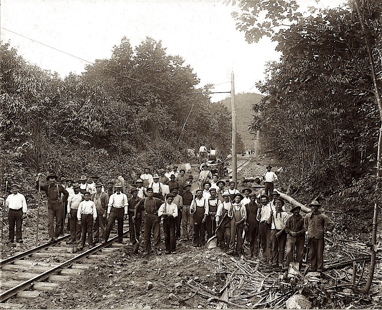
Workers installing wire take a break to pose for this picture along the Holyoke Street Railway trolley line between Northampton and Holyoke in the early 1900s.  In the background is Mt.Nonotuck. (Seminole Bailey Archives)


Thursday, September 8, 2016

Mt.Tom - Whiting Street Reservoir - early 1900s


A family poses for a picture on the cliffs of Mt.Tom around 1915. This photo was taken near the Tea Pavilion on the east side of the mountain with the Summit House in the background.


A wide angle view of the Mt.Tom Summit House just above the Tea Pavilion on the east side of the Mt.Tom summit. The stone foundation of the house still stands, part of the radio communications building.


 Looking southwest towards Ashley Reservoir from the western cliffs of Mt.Tom.


 The basalt cliffs on the west side of Mt.Tom just below the MM Trail of the Mt.Tom Range.


A southwest view of Mt.Tom with Whiting Street Reservoir in the foreground taken from Mountain Park near the trolley line to Lower Station  in the early 1900s.  (Photos courtesy of the Seminole Bailey Archive)

Thursday, September 1, 2016

C. H. Tower Residence

The home of C.H. Tower at the southeast corner of Lincoln and Pleasant Streets in the winter of 1911. (The Seminole Bailey Archives)

Sunday, April 24, 2016

B&M Railroad 1950s


Engine 4214 heading north pulling freight near Pulaski Park and the first level canal in the 1950s. In the background is the Whiting Paper Company. (Photo courtesy of the Edwin Bill Robertson Collection)

Sunday, February 21, 2016

Central Vermont Railroad

Engine 600 of the Central Vermont Railroad heading south near the Holyoke Cove in the 1930s. (Seminole Bailey Archive)

Sunday, November 15, 2015


Windsor Hotel 1880s


The Windsor Hotel was located at the northeast corner of Dwight & Front Streets. The hotel was erected by William Whiting who was head of the Whiting Paper Co. Whiting would go on to serve as mayor of the city and later Congressman. 

Also partially visible behind the hotel on Front Street (right) is the Holyoke Opera House. The hotel was destroyed by fire in 1899 while the Opera House stood for many years when it too was destroyed by fire in October of 1967.

Saturday, October 31, 2015

Third Mt.Tom Summit House

After fire destroyed the second Summit House in 1929 (the first house was also destroyed by fire in 1901),  a third house was built just north of where the first two houses stood.  It was nowhere near as majestic as the previous houses, just a simple steel frame and corrugated metal sided structure. The house remained open until 1936 when trolley service along with the Mt. Tom Railroad ceased operation, and stood until 1939 when it was scrapped along with the incline rail line.  All that remains today of the third house is a concrete stairway and the concrete foundation blocks on which the house rested upon.


A visitor to Mt. Tom stands in front of the third Summit House in June of 1934. (Seminole Bailey Archive)

Saturday, October 24, 2015

Before Amtrak....


Central Vermont Engine 231 travels north near Smiths Ferry in the late 1930s. Passenger service ran through Holyoke up until the early 1970s with the old Montrealer line and has now returned with Amtrak's rail service. (Seminole Bailey Archive)

Friday, October 16, 2015

The Orient Restaurant


Dubbed "Holyoke's Restaurant Beautiful", The Orient was a Chinese-American restaurant located at 515-519 Dwight Street downhill across from the City Hall. This photo, from the early 1930s, shows the trolley tracks and cobblestone that was paved over in the early 1940s after the demise of the trolley lines. (Seminole Bailey Archive)